Low Flying Planes Sighted Over Portland – However, There Is A Simple Explanation
It’s always a little concerning to see a low flying plane over an urban area. This is a natural thing to feel since most of the time, there is almost no need at all to fly so low over residents houses and businesses.
However, yesterday, Portland locals in the North East area saw multiple planes and helicopters flying extremely low to the ground, which left them scratching their heads. Using the website FlightRadar, we can see that some of these aircraft were flying between 150 – 500 feet from the ground, which is very low indeed!
However, as with most things in life. If you follow the logic, then soon enough you will find out what the answer is.

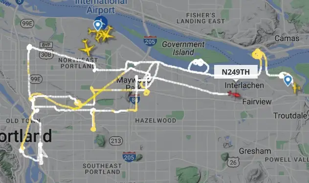
As you can see, the helicopter flight path is in dark orange, showing that it was well under 600 feet. You may have also noticed that the flight path is extremely straight, as if the chopper were driving on a road.
This is because a clever group of Portland locals figured out that Pacific Power was taking a look at their high voltage power lines. The above image is pretty much exactly where all of the power lines run from – which makes sense why the flight path is so straight. Also, the circular pattents appeared when the helicopter was circling over substations.
So overall, this may have been concerning to watch without any information about what was going on. But in reality it was just a harmless and boring power line inspection.
For those wondering, here is some more information about aerial surveys – and more importantly why they are used:
Aerial surveys are commonly used in various industries, including the energy sector, to assess and monitor the condition of power lines and other infrastructure. Aerial surveys offer several advantages over ground-based inspections, such as:
- Efficiency: Aerial surveys can cover large areas quickly, allowing for a comprehensive assessment of power line networks in a relatively short amount of time.
- Accessibility: Power lines often traverse difficult terrain or inaccessible areas. Aerial surveys provide a way to access and inspect these locations without the need for ground-based personnel to navigate challenging landscapes.
- Safety: Conducting inspections from the air reduces the risks associated with working at heights or in hazardous environments. It minimizes the need for workers to physically access power line structures.
- Data Accuracy: Aerial surveys can capture high-resolution imagery or LiDAR (Light Detection and Ranging) data, providing detailed information about the condition of power lines and their surrounding environment. This data can be used to identify potential issues, such as vegetation encroachment, structural damage, or equipment wear and tear.
By utilizing drones, helicopters, or specialized aircraft equipped with advanced imaging technologies, utility companies and maintenance teams can assess the health of power lines, identify maintenance needs, and plan for infrastructure improvements more effectively.

What accommodation has been made for drones, which can legally fly up to 400′?