Portland Without A Car – Is It Possible?
Portland, Oregon, stands out as a model city for public transportation in the U.S., and there are several reasons for its acclaim. Central to its success is the comprehensive TriMet system, which seamlessly integrates buses alongside the MAX, ensuring expansive coverage across the city and its suburbs.
Additionally, Portland’s commitment to sustainability and reducing carbon emissions has led to consistent investments in clean and efficient transit options. For those looking for on-demand mobility without the commitment of car ownership, the city also supports car-sharing programs and has a growing network of bike lanes and bike-sharing services.
In summary, Portland is an easy city to live in without a car, especially when compared to other cities in the USA. Having a car goes from near essential in the outer suburbs of Portland with poor bus and no MAX coverage, but the closer you live to central Portland, the easier it becomes to live without a car. As public transport is very good and affordable, cars are not 100% needed. Furthermore, if you enjoy walking and cycling, Portland is easy to navigate.
Living in specific neighborhoods of Portland without a car:
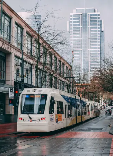
Downtown and the Pearl District:
Public Transportation: These areas are well-served by the TriMet system, which includes buses, and the Portland Streetcar. The Transit Mall on 5th and 6th Avenues is a hub for many bus lines.
Walkability: Downtown and the Pearl District are among the most walkable areas in Portland, with numerous shops, restaurants, parks, and cultural institutions within walking distance.
Biking: These areas have several dedicated bike lanes and bike-sharing options.
Inner Eastside (including neighborhoods like Belmont, Hawthorne, and Division):
Public Transportation: Well-connected by bus routes and the MAX light rail, especially along major corridors.
Walkability: Many of these neighborhoods have commercial strips with cafes, shops, and services, making them highly walkable.
Biking: The Eastside has a grid layout, which is conducive to biking. There are also several bike boulevards and dedicated lanes.
North Portland (areas like St. Johns and Mississippi):
Public Transportation: Served by several bus routes, and the MAX Yellow Line connects North Portland to Downtown.
Walkability: Areas like Mississippi Avenue and St. Johns have vibrant commercial districts that are pedestrian-friendly.
Biking: There are bike lanes and paths, including the scenic route along Willamette Boulevard.

Northeast Portland (neighborhoods like Alberta and Hollywood):
Public Transportation: Good bus connectivity and the MAX Red, Blue, and Green Lines serve parts of Northeast Portland.
Walkability: Commercial areas like Alberta Street and the Hollywood District are walkable with a mix of shops, restaurants, and services.
Biking: The area is bike-friendly with dedicated lanes and bike boulevards.
Southeast Portland (areas further out like Lents and Foster-Powell):
Public Transportation: While still served by buses and the MAX Green Line, the frequency is considerably less than in inner neighborhoods.
Walkability: Some parts are walkable, especially around commercial strips, but other areas do require longer walks or rides to access services.
Biking: The area is expanding its bike infrastructure, but some parts might lack the dense network found in inner neighborhoods.
Southwest Portland and the West Hills:
Public Transportation: Served by buses, and the MAX Red and Blue Lines connect parts of Southwest to Downtown and other areas. However, some hilly or suburban parts might have less frequent service.
Walkability: This varies. Some areas, especially those in the hills or more suburban parts, are less walkable than the flatter, urban parts of the city.
Biking: The hilly terrain can be challenging for less experienced cyclists, but there are still bike routes and paths.
